
 Departamento de Conservación y Recreación (DCR)
 Conservar. Proteger. Disfrutar.
Departamento de Conservación y Recreación (DCR) 


Understanding flood risk requires knowing which areas of your community are exposed to flooding today, and which areas are expected to be exposed in the coming decades. Due to changing patterns of precipitation, sea level rise, and development, historic flooding trends are no longer a useful predictor of future risk.
Nationwide, we lack consistent, locally specific data that forecasts flooding based on multiple risk sources. The Commonwealth is closing these data gaps and providing data tools to support flood resilience planning efforts in Virginia.
DCR provides two non-regulatory flood hazard datasets that can be used together with regulatory data to support more informed flood resilience planning: a coastal Virginia flood hazard dataset (developed for the Coastal Resilience Master Plan) and a statewide Fathom flood hazard dataset (procured for the Virginia Flood Protection Master Plan). The table below explores and compares these two resources. In addition, DCR provides flood impact data for coastal Virginia to explore how assets may be affected by flood conditions. Users can access and explore this resource via the Coastal Resilience Web Explorer.
|
Coastal Virginia Flood Hazard Data |
Fathom Flood Hazard Data |
Geographic Area |
Coastal: localities within any of the eight easternmost Planning District Commissions in Virginia. |
Statewide: The entire Commonwealth of Virginia. |
Flood Hazards |
Coastal, riverine, and rainfall-driven flooding |
Coastal, riverine, and rainfall-driven flooding |
Recurrence Intervals |
Seven recurrence intervals: 1 in 2-, 5-, 10-, 25-, 50-, 100-, and 500-year. Three tidal conditions (MLW, MHW, 1.5xMTR) are also available for coastal flood data. |
Five recurrence intervals*: 1 in 10-, 25-, 50-, 100- and 500-year. |
Associated DCR Plan |
Coastal Resilience Master Plan (CRMP) |
Virginia Flood Protection Master Plan (VFPMP) |
Planning Scenarios |
Five planning scenarios: baseline (2020), plus “moderate” and “high” scenario options for the near future (2030-2060) and far future (2060-2100) time horizons. |
Five planning scenarios: baseline (2020), plus two “moderate” and “higher” scenario options for the 2060- and 2100-time horizons. |
Basis for Future Conditions |
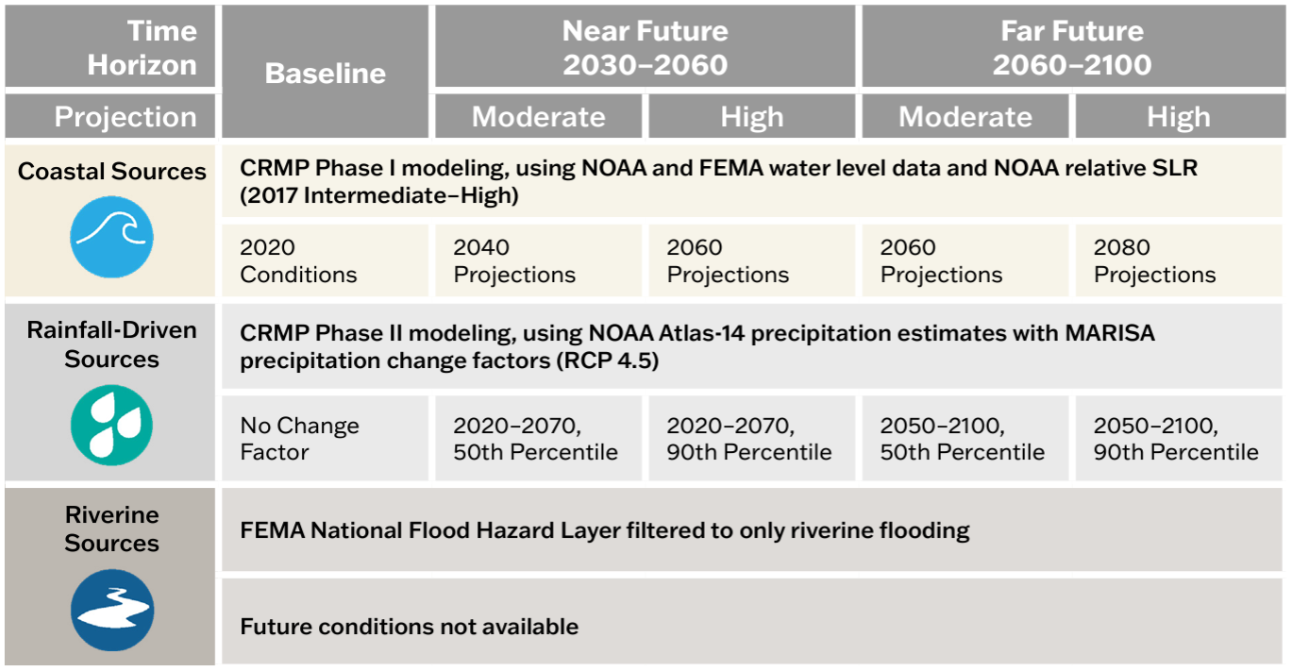
Varies by flood source and planning scenario. See reference figure for more information. |
Shared Socioeconomic Pathway 2-4.5 (SSP2-4.5). “Moderate” scenario based on median (50th percentile) values and “higher” scenario based on 83rd percentile values. |
Resolución |
10-foot |
10-meter (~33-foot) |
Fuente |
DCR with underlying data from the United States Army Corps of Engineers, the National Oceanic and Atmospheric Administration, and the Federal Emergency Management Agency. |
Fathom |
Acceso |
View and download data and methodology documentation via DCR’s Flood Resilience Open Data Portal. |
View the 1 in 100- and 500-year data for baseline conditions via DCR’s Flood Resilience Open Data Portal. Access to all other products is provided to VA public institutions.* |
Información adicional |
Learn more via the overview one-pager. Learn more about Flood Hazard Data Development in Appendix A of the CRMP Phase II. Learn more about the asset data and impact assessment methodology in Appendix B of the CRMP Phase II |
Learn more via the overview one-pager. |
*Virginia government entities and state-recognized Tribal governments may sub-license all Fathom data from DCR for a 12-month renewable license term. To inquire about a sub-license agreement, including data use limitations, please contact us at flood.resilience@dcr.virginia.gov.
Additional data to visualize and understand flood hazards is available through state and federal platforms. Below is a snapshot of these data resources which can be accessed through the links provided.
There are many tools to aid organizations in crafting a flood resilience plan. Below is an abbreviated list of useful planning tools. Additional tools can be found on the information gateways linked below.
The following tools were developed with Virginia-specific needs in mind. While some are focused on exploring flood resilience specifically, others support resilience planning more broadly.
Federal agencies have developed tools to assist organizations to plan and implement successful flood resilience strategies. The following resources may help you to craft your resilience plan.
These portals and databases contain a variety of resources – such as data, planning tools and funding information – that may be useful to your organization as you develop your resilience plan:
Organizations developing flood resilience plans should consider approaches which align both with DCR’s flood resilience plan guidance, as well as with federal resources and funding opportunities. Resources to help you understand how to align your approach to resilience planning with available funding resources include:
DCR administers the Community Flood Preparedness Fund (CFPF) and the Resilient Virginia Revolving Fund (RVRF). For more information on these funds visit the DCR Floodplain Management, Flood Resilience Funding website.
Beyond the DCR administered resilience funds, the Coastal Resilience Web Explorer Funding Opportunities tab provides an inventory of funding sources that may be available to finance the development and/or implementation of your plan. While it is catered to the coastal region, non-coastal activities may be eligible for some listed opportunities.
The DCR Flood Resilience Funding Geographic Focal Area Viewer identifies geographic areas that are designated as either required or preferred for resilience funding, including Low-Income Geographic Areas for the DCR Community Flood Preparedness Fund.
Los informes históricos relevantes para la planificación de resiliencia a las inundaciones en Virginia se archivan a través de los menús desplegables a continuación.
Durante la sesión de la Asamblea General de 2024, el proyecto de ley de la Cámara de Representantes 1458 modificó los requisitos del Reporte sobre el Estado de la Resistencia a las Inundaciones del Código de Virginia (§ 2.2-220.5). para incluir el estado de la resistencia general en la Commonwealth, incluida la resistencia a las inundaciones. Publicado en julio de 2025 y cada dos años a partir de entonces, el reporte incluye el estado de las acciones emprendidas por el Director General de Resiliencia y las agencias estatales en materia de coordinación y planeación de la resiliencia y toda la financiación para la resiliencia recibida y distribuida por la Commonwealth durante los dos años anteriores.
Lea la actualización del estado de la resiliencia2025 en la Commonwealth of Virginia
Durante la sesión de la Asamblea General de 2024, el proyecto de ley de la Cámara de Representantes 1458 modificó los requisitos del Reporte sobre el Estado de la Resistencia a las Inundaciones del Código de Virginia (§ 2.2-220.5). para incluir el estado de la resistencia general en la Commonwealth, incluida la resistencia a las inundaciones. Publicado en julio de 2025 y cada dos años a partir de entonces, el reporte incluye el estado de las acciones emprendidas por el Director General de Resiliencia y las agencias estatales en materia de coordinación y planeación de la resiliencia y toda la financiación para la resiliencia recibida y distribuida por la Commonwealth durante los dos años anteriores.
El Centro de Políticas Públicas (CPP) de la Universidad de la Mancomunidad de Virginia (VCU, por sus siglas en inglés) facilitó el RCWG con el apoyo financiero del Centro de la Mancomunidad para la Resiliencia ante Inundaciones Recurrentes (CCRFR, por sus siglas en inglés).
En 2023, el Director de Resiliencia de la Commonwealth publicó un informe bienal al Gobernador y a la Asamblea General sobre el estado de la resiliencia a las inundaciones en Virginia de conformidad con el Código de Virginia (§ 2.2-220.5).
Lea el reporte sobre el estado de la resiliencia ante inundaciones de2023 .
